Into the
W!Ld
Paithalmala Trekk!
Introduction
Pythal Mala is an enchanting hill station, situated 4,500 ft. above sea level near the Kerala - Karnataka border, is rich in flora and fauna. It is a 6 km trek to the top of the hills.
Abundant in flora and fauna, this place is now being developed as a hill resort. One has to trek 6 kms to reach the top of the hills. There is a proposal to set up a zoo at the top of the hill.
The enchanting hill station offers a challenging trek to those inclined to stretch their legs. Trekkers are rewarded by a profusion of exotic flora and fauna and an exhilirating view from the top.
The 300 acre wide sprawling area is a safe home to numerous birds, hundreds of butterflies, rare plants and trees. Even during this sweltering summer at Paithal Mala one can relish a real cool climate. En route to the top of the hill one can see the remains of the run down palace of the tribal king called Vaithalkon.
Getting there and around
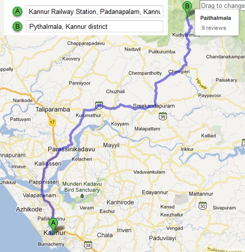
Nearest Bus Station : Pottenplave (KSRTC is running several buses to Pottenplave from Kannur & Payyannur depots).
Nearest Railway Station : Payyanur railway station / Kannur railway station.
Nearest Airport : Calicut International Airport / Mangalore International Airport.
The hill top can be reached from two different directions; pottenplave (near Kudiyanmala) and Kappimala (Near Alakkodu). However, trekking from pottenplave is preferred because of the all-weather motorable road from pottenplave till the beginning of the forest, where the trek starts. There are upcoming resorts on this route too. The drive from Kudiyanmala till Paithalmala valley is refreshing as the winding and narrow road takes you to the higher elevations. Cars can be taken here without a second thought too. Parking at the valley is not guarded but generally safe.
Things to do.
The main activities you can indulge in are adventure, photography and trekking. Best place to feel nature and alot of study if you are a Botanist.
Things to carry
Do you have the following backpacks
- Food /Snacks / Chocolates (Take care not to litter the place with food stuffs and plastics. Alcohol is banned and you can get into trouble if you are carrying it)
- Water
- Salt(To fight your way through leaches)
- Camera
- Bedsheets and Towels and an extra clothes
- Sweaters and thick blankets.
- Tarpolin sheets
- Thick socks and shoes
- Cap or suncream lotion
His Experience
Pythalmala / Pythal Mala / Paithalmala / Vaithalmala is the tallest peak in Kannur district of Kerala. I'd been hearing about this place for a while now - but what piqued my interest recently was the pictures shared by Jinu[1] from his trek to Pythalmala and Kanjirakolly / Kanjirakolli. Later in a chat, he mentioned that Thadiyandamol ranges are very near to Pythalmala and he actually did a trek from Thadiyandamol to Kanjirakolly[2]. On hearing that Thadiyandamol ranges is clearly visible from Pythalmala, I knew I had to go :)
According to Jinu, rainy season is when the place comes alive with its share of mist and mysteries, but I felt that the views will be clearer in summer. I was planning to go to Kozhikode - my home town - on one of the weekends and planned to visit Pythalmala along with it. When I checked with Jinu, he was more than willing to join!
The plan was to drive down to Kozhikode on saturday morning, stay home for a day and then head to Pythalmala early morning next day. Jinu would take a bus to Kannur and join me on the way - at Mattannur. After the trek at Pythalmala, we would also go to Kanjirakolly and then drive back to Bangalore on the same day evening - a little hectic, but it was always fun that way :)
As planned, I reached Kozhikode by saturday noon. Next day, early morning - by 4 - I got ready to drive down towards Kannur. My parents got up along with me as they refused to let me go without having breakfast. Amma made me some yummy dosas and coconut chutney and I was left wondering if I could get a better start than this :)
It was about 4.30 by the time I was on road - a little late than planned and I had to make it up. The road was smooth and I could zip through the NH17 quickly. I passed Koyilandy, Thikkodi, Payyoli and Vadakara bypass in no time to reach Mahe by 5.30. The road from Mahe onwards is quite narrow though - resembling a residential area more than a national highway. It took me a while to wade through the streets of Mahe and then Thalassery. In the process I missed the road towards Koothuparmba - Mattannur - Iritty road and ended up heading towards Kannur.
By now, Jinu messaged me that he already reached Mattannur. It took me some more time before I took the turn towards Mattannur at Mele Chovva and reached Mattannur via Koodali. When I reached Mattannur by 6.15, Jinu was waiting for me, after having his share of breakfast and news paper at a shop near Mattannur bus stand. Soon, we were headed towards Pythalmala.
Pythalmala is accessible from Kudiyanmala and Kappimala, near Payyavoor. Both places have motorable roads for some distance. At Kudiyanmala a new govt resort is coming up and there is a motorable road via Pottanplavu, which goes till the resort. The peak is a little more than an hours trek from the resort.
From Mattannur, we could take the Irikkur - Sreekandapuram - Payyavoor route or the Iritty - Ulikkal - Payyavoor route. After asking a few people, we ended up taking the later. At Payyavoor, we took the road towards Chemperi and then turned towards Kudiyanmala. The roads till here had its share of potholes, but decent to drive on. At Kudiyanmala, we headed towards Pottanplavu from where the newly constructed road to Pythalmala starts.
We crossed a bridge here, but the stream was dry now. A board there indicated a waterfalls. Jinu mentioned that it is a 7-stage waterfalls, which looks quite stunning in the monsoon. But, the stream was obviously dried up in the summer. It is here that the ascend became really steep. The road was narrow too with its share of potholes, forcing Versa to stay in 1st gear for most parts.
Jinu mentioned that the place is extremely beautiful and dreamy, covered with mist, during monsoon. Even though, summer had just begun, the surroundings were green - there were flowering trees on both sides making it a pretty ride. There is a private resort too on the way up, where Jinu had stayed once. Apparently, they have a dormitory too, ideal for people coming there for treks. They could also keep the lunch ready if we inform them on our way up.
By 8, we were at the govt resort which is not yet operational. We parked the car outside and picked up our bags, which practically had nothing in it. This is when we noted that we had only one bottle of water - but it was only an hours trek and this one should suffice. Jinu was also carrying a GPS on which he wanted to mark the trail. Soon, we were on our way up to Pythalmala.
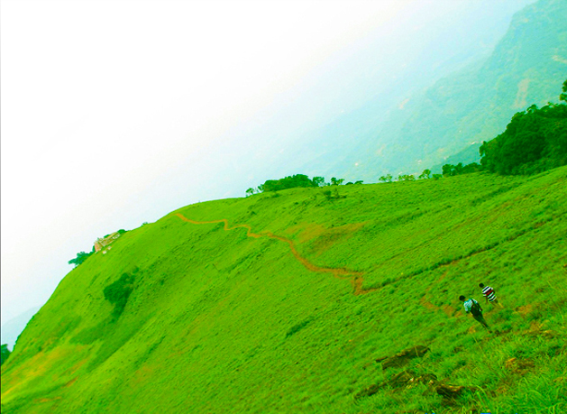
A portion of the peak was visible from the starting point and it looked quite near. The trail had good forest cover to start with and the ground had a layer of dry leaves. It was an almost level trail with a very small ascend. 10-15 minutes in to the trail, there was an opening to our left with a view of the hills. In another 10 minutes we emerged out of the forest trail in to an open grass land, with a watch tower to our left.
It had taken us only about 30 minutes to reach this grass land and may be another 15 minutes to reach the watch tower. I looked around and felt that the hill is taller to the right side - so that could extend the trek for some more time. But, at this point of time, it did not look like the trek was long enough for a good warm up!
We headed towards the watch tower looking around trying to identify the hills / villages around us. The watch tower was towards south east overlooking Kudiyanmala and surrounding villages. The taller part of the hill behind us curled westwards forming a ridge. As we moved down towards the watch tower, we could also see the resort towards east. Far behind the hill housing the resort, we could spot the silhouette of a few tall hills. Now, that should be the Thadiyandamol ranges in Coorg!
The watch tower was a dilapidated concrete building which did not offer any better views than from the ground. For me, it looked like an eye-sore to an otherwise very natural surroundings. Jinu mentioned that there is a view point further down the hill. I was more interested heading to the taller part of the hill, but agreed to go down-hill for a view.
The fenced view point looked pretty with the greenery around it and a little bit of mist thrown in. We sat there for a while trying to identify places down below. Jinu opened a biscuit packet too for us to munch on. There were chirrups of birds all around us adding to the beauty of the place. There was also a group of swallows, moving around, making a "swoosh" sound as they passed us. I could imagine how verdant and dreamy the place can look during monsoon.
On our way back, I could spot a Shikra seated on one of the trees, but it flew away when I tried to get closer for a clean picture. Later, it came back for another round and then did a breathtakingly fast descend as we were watching.
Back at the watch tower, another group of guys had taken over the place and we did not stop. Soon, we were going up the hill looking for the peak. The hill looked like a ridge (east to west) and the entire length looked to be of the same height. The eastern edge of the ridge had thicker forest cover, but the western end looked grassy. We followed a trail going towards the western side and soon reached the top of the ridge for a beautiful view of the other side of the valley.
The range of hills towards north east now looked closer and quite majestic. We concluded that the peak in this range - furthest away from us - has to be Thadiyandamol. There was a village on the north-west side and we could spot a few trails leading to it. This had to be the Kappimala village.
The trail continued on top of the ridge and we took a leisurely walk along it, following the minor ups and downs in it. We had ran out of water, but we did not worry much as the trail was not so hard. Further down, mist started building up negating the sun and a cool breeze ensured that the walk was enjoyable.
The Shikra, that we saw near the view point, was now flying around here and we kept seeing it in regular intervals. It even came flying near us a couple of times, but chose to sit far away from us. Unfortunately, I could not manage any good shots of the birds accrobatics in the air.
There were two small minor hills on the ridge on top of which Jinu measured 1220m on his GPS. As we got down from the second hill, we could see a trail leading towards the village. Jinu was quick to note that a trek from Kappimala via Pythalmala, till the resort would be a good trek and started planning for it! With all the ridge walking this was already a good trek for me :)
Now, the altitude started dropping and the trail re-appeared leading us back towards the resort. At about 12, we were back at the point where the trail emerged out of the forest cover. Jinu's water bottle was empty by now and I was feeling quite dry. Again, it did not matter much as the resort was only about half an hour away.
There were a few groups of people heading towards the hills and they were carrying liquor bottles with them. Looked like the tallest peak in Kannur has become a weekend boozing point! As expected, we were back at the resort about half an hour later. There were a few cars parked around there by then and it was quite hot. We were soon on our way back and stopped at Pottenplavu to buy water. Half an hour later, we went past Kudiyanmala and stopped at a hotel on our way to Payyavoor. We were both quite hungry by then and hogged on until our stomachs couldnt take any more!
From Payyavoor, we headed towards Kanjirakolly. The highlight of this stretch was the cashew trees lining the road and we stopped quite a few times to steal some juicy cashew fruits. It reminded both of us of the childhood days when chasing mangoes and cashews were part of the day.
Kanjirakolly has its share of picnic spots as well - a few hills and view points, a waterfalls called Alakapuri and a cave called Chittari. The waterfalls would have been dry at this time of the year and we did not have time for much sight seeing. So, our only plan was to visit a view point called Sasipara, which offers a good view of the Thadiyandamol ranges.
So, at Kanjirakolly, we headed straight to the Sasipara road. According to Jinu, there is a trek trail from Kanjirakolly, leading up to Sasipara, but I did not want to risk getting late. The road was steep yet again and there was not enough space when we encuntered a couple of bikes on its way back. Most of the distance was covered in 1st gear. The final 1km was not tarmac laid and Jinu suggested that we park the car there and walk the last mile. I agreed as the road looked full of huge stones.
Ten minutes later, we were at the Sasipara view point overlooking the Thadiyandamol ranges towards north. It would be fun to walk down those hills to reach Thadiyandamol - but that was for another day!
It was 3.30 by then and time to head towards Bangalore. We did not have to go back to Payyavoor, instead we were at Ulikkal, by about 4. From Ulikkal, there is a road connecting to Vallithode near Koottupuzha (on Iritty - Virajpet highway). But we missed it and went to Iritty to enter the same highway.
Driving through the reserved forest was an interesting experience too as we spotted couple of birds, including two emerald doves - a first for me. Even after reaching Perambady, near Virajpet, we could sight many interesting bird species. But, the light was already fading and photography was not much of a success.
The Perambady - Bittangala bypass road was in a very bad condition and even the Bittangala - Gonikoppal - Hunsur highway was full of potholes. But, we managed to reach the Madikeri - Mysore highway before Hunsur and after that the roads were quite good - except for the under-upgrade-to-4-lane Mysore ring road. After dinner at Mysore, we had a breezy drive to Bangalore, reaching the city by about 11.30.
Trek to Pythalmala was a short one, but introduced me to a whole new area of Western Ghats hitherto unknown to me. Now, it will be tough to get good sleep until I make another trip to Thadiyandamol - preferably to go on all the way to Kannur.
